
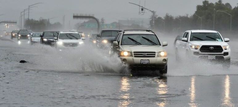
The National Weather Service issued a Flood Watch for the Bay Area for this Wednesday and Thursday. Last weekend’s atmospheric river brought 1.74 inches of rain to San José.
“A potent Pineapple Express will move into the region Wednesday and continue into Thursday,” the Weather Service reported. “This will bring substantial rainfall to the Bay Area and Monterey Bay region on top of already saturated soils.”
Forecasters predicted rapid rises in area creeks, streams and rivers.
The City of San José proclaimed a State of Emergency for the duration of the current atmospheric river weather event. San José Mayor Matt Mahan urged residents to prepare for the heavy rains.
The proclamation provided emergency powers for the city’s anticipated response and issued an evacuation order to people living near waterways.
“San Jose is taking this extra precautionary step during this storm surge to protect our residents, particularly our most vulnerable unhoused neighbors,” Mahan said. “We want to make sure … city staff has the ability to move quickly to relocate encampments that are in harm’s way.”
The Flood Watch will remain in effect from late tonight through Thursday afternoon.
Flooding could occur in Santa Clara Valley Including San Jose, Santa Cruz Mountains, portions of central California and northern California, including the following areas: central California, mountains of San Benito County and Interior Monterey County including Pinnacles National Park, Northern Salinas Valley/Hollister Valley and Carmel Valley, Santa Lucia Mountains and Los Padres National Forest, Southern Monterey Bay and Big Sur Coast and Southern Salinas Valley/Arroyo Seco and Lake San Antonio. In northern California, Coastal North Bay Including Point Reyes National Seashore, East Bay Hills, East Bay interior valleys, Eastern Santa Clara hills,Marin coastal range, North Bay interior mountains, North Bay interior Valleys, Northern Monterey Bay, San Francisco, San Francisco Bay Shoreline, San Francisco Peninsula Coast, and Sonoma coastal range.
“Excessive runoff may result in flooding of rivers, creeks, streams, and other low-lying and flood-prone locations,” according to the Weather Service. “Creeks and streams may rise out of their banks. Flooding may occur in poor drainage and urban areas. Low-water crossings may be flooded. Storm drains and ditches may become clogged with debris.Extensive street flooding and flooding of creeks and rivers are possible.”
Valley Water reported it is closely monitoring the storm and potential flooding including:
- Uvas Creek, with potential flooding of Highway 101 south of 10th Street in Gilroy
and the area of the Gilroy Sports Park - San Francisquito Creek in Palo Alto
- Ross Creek at Cherry Avenue in San Jose
- Upper Penitencia Creek at Mabury and King roads in San Jose
- Guadalupe River at West Alma Avenue in San Jose
- Sunnyvale East Channel at Tasman Drive in Sunnyvale
- West Little Llagas Creek in Morgan Hill
Valley Water has identified these locations as hot spots. But it is important to note that the
potential areas of flooding are not limited to only these locations.
High Wind Warning
To make matters worse, the National Weather Service also issued a High Wind Warning, in effect from 4pm Wednesday to 10am Thursday.
Forecasters predicted southerly winds 20 to 30 mph with gusts up to 50 mph in valley locations. 30 to 40 mph with gusts up to 60 mph above 1000 feet, with local gusts to around 70 mph on the coast and at highest peaks.
The damaging winds “will blow down trees and power lines. With widespread power outages expected.”
The weather service warned that “saturated soils will allow for trees to topple more easily during this prolonged wind event. The strongest winds will be during the cold frontal passage late Wednesday afternoon through early Thursday morning.
Santa Clara County residents can get free filled sandbags from sandbag sites operated by the Santa Clara Valley Water District ahead of more heavy rainfall expected this week.
Heavy winter rainfall can cause flooding in minutes but homeowners can use sandbags to prevent or reduce damage from floodwater or debris. The sandbags are available at five Valley Water sites.
Valley Water sandbag guidelines say it's most effective to put a tarp between a structure and sandbags to keep flood water from seeping between the housing siding and foundation sills
The Foothills Nature Preserve will be closed on Wednesday and Thursday due to the anticipated weather.
Northbound state Highway 1 in Santa Cruz fully reopened across the San Lorenzo River early Tuesday morning.
The highway, which reopened around 5 a.m., had been closed over the San Lorenzo River since 2pm Sunday to allow Caltrans workers to clear debris that has accumulated under the bridge from Saturday's storm.
The First Atmospheric River
A second one is headed our way Wednesday.
It's a stormy start to the morning in the western U.S. Water vapor imagery from @NOAA's #GOESWest is showing a Pacific storm spinning southwest of Alaska while a plume of atmospheric moisture streams into the West Coast. Flood Watches are in effect for much of California. #CAwx pic.twitter.com/UOw84dSD9x
— NOAA Satellites (@NOAASatellites) December 29, 2022