
Originally published in the New York Times Magazine, June 22, 2023
On the morning of Feb. 7, 2017, two electricians were working on a warning siren near the spillway of Oroville Dam, 60 miles north of Sacramento, when they heard an explosion. As they watched, a giant plume of water rose over their heads, and chunks of concrete began flying down the hillside toward the Feather River.
The dam’s spillway, a concrete channel capable of moving millions of gallons of water out of the reservoir in seconds, was disintegrating in front of them If it had to be taken out of service, a serious rainstorm, like the one that had been falling on Northern California for days, could cause the dam — the tallest in the United States — to fail.
Oroville is an earth-fill embankment dam with a clay core and a surface of loosely placed rocks. These structures can be incredibly resilient, especially to earthquakes — concrete dams like Hoover Dam are rare in seismically active California — but they are also more vulnerable if overtopped. Once water overwhelms the spillway and starts flowing over an embankment dam, its layers can melt away at an astonishing speed. If Oroville failed in this way, it would send a wave more than 185 feet tall sweeping into the valley below.
On the afternoon of Feb. 12, 2017, state water officials concluded that within two to four hours, the dam’s emergency overflow – which had never been used in the 50-year history of the dam – would fail, sending a wall of water as high as 50 feet rushing toward town.
Kory Honea, the sheriff of Butte County, issued a mandatory evacuation order.Approximately 180,000 people ended up having to leave their homes under a mandatory evacuation order..
After the evacuation, the situation at the dam stabilized. The rain let up, and the main spillway, although badly damaged, was able to channel enough water out of the reservoir to drop the level below the top of the emergency spillway. Slowly, the townspeople returned to their homes.
Today the dam has two new spillways, each of which survived major rains this spring with no problems. According to Honea, though, the people of Oroville remain traumatized.
A wake-up call for dam safety
An independent forensic report on the Oroville Dam overflow faulted an “immature,” “significantly overconfident and complacent” culture at the California Department of Water Resources.
Officials ignored reports about the flawed rock below the emergency spillway, made repairs in a haphazard way and failed to find flaws in the spillway design — most notably drains that made the concrete more susceptible to cracking.
The report also noted that this attitude is typical among large dam owners: “The fact that this incident happened to the owner of the tallest dam in the United States, under regulation of a federal agency, with repeated evaluation by reputable outside consultants, in a state with a leading dam-safety regulatory program, is a wake-up call for everyone involved in dam safety.”
In the six years since Oroville, dam operators across the country have begun to reassess the structures under their control, looking for hidden weaknesses: the cracks in the spillway, the hillside that crumbles at the first sign of water. That work is necessary, but it may not be enough to prevent the next disaster.
Bigger storms are on the way
“We still haven’t severely tested California’s primary flood-control structures,” says Daniel Swain, a climate scientist at the University of California, Los Angeles. The emergency spillway at Oroville, for example, was operating at about 3 percent of its capacity when Honea ordered the evacuation. “If we had an even marginally bigger event on the weather front that year,” Swain says, “it would have been significantly worse.”
Climate Forward There’s an ongoing crisis — and tons of news. Our newsletter keeps you up to date. Get it in your inbox.
Dale Cox, a former project manager at the United States Geological Survey who has worked extensively with Swain, told me that California’s dams are unprepared for extreme weather because state water authorities have a false sense of how bad flooding can get. “The peak of record is driving a lot of engineering decisions in the state,” he says, and that peak is an underestimate, maybe a gross one. “Already, we are seeing several 100-year floods every 10 years.”
California dams are ‘unprepared’ for climate change
Some of this miscalculation arises from the state’s failure to account for climate change, a problem that will only get worse as the atmosphere heats up and the amount of water vapor it can carry increases.
“All of this infrastructure,” Swain says, “is designed for a climate that no longer exists.” But the error also lies in our understanding of the past. Most of the flood data that form the basis for the design of California’s dams come from the past century, which was an unusually placid period in the state’s weather.
Around three decades ago, meteorologists’ mental map of the state was given a jolt when satellites became sophisticated enough to pick up what came to be called atmospheric rivers. These storms, which resemble a lasso of rain thrown across the Pacific Ocean to the West Coast, deliver what Swain described to me as “almost incomprehensible volumes of water.”
In the mid-2000s, Cox assembled a group at the U.S.G.S. to study what would happen if the atmospheric rivers from two notable California flood years, 1969 and 1986, occurred back to back.
They named the resulting scenario the Arkstorm: flooding throughout the state, water depths of up to 20 feet in the Central Valley and economic losses of $725 billion. When the report on this research was done, the authors presented it to emergency managers, municipal authorities and dam owners, including the Department of Water Resources.
The response was demoralizing. “They said, ‘That’s too big, that’s ridiculous,’” says Lucy Jones, the chief scientist for the project.
The authors of the Arkstorm report had a response ready, however. Their imaginary storm was modeled on the Great Flood of 1862, which also made a lake of the Central Valley and destroyed, by one account, a quarter of all the buildings in the state. “The minute that you say this is too big, this couldn’t happen, this is unrealistic,” says Michael Dettinger, a hydrologist who worked on the report, “I can just point at 1862 and say, ‘1862 was far worse than this.’”
In April 2021, Cox took me on a walk along the American River, about 30 minutes northeast of Sacramento. Somewhere downstream of Folsom Prison, he said, was a reliable high-water mark for the 1862 flood. Because it was so long ago, water authorities didn’t count it as an official peak of record, but it showed what the river was capable of.
Dam failures can be deadly
Dam failures are rare, but when they happen, they can be deadly. Nearly as many lives were lost following the 1889 collapse of the South Fork Dam near Johnstown, Pa., as in the attack on Pearl Harbor.
When St. Francis Dam near Los Angeles breached in 1928, it unleashed a wall of water that was initially 140 feet tall, carrying off people and houses and animals before emptying into the Pacific Ocean some 50 miles away.
And yet dam safety is an orphaned problem. Meteorologists tend to talk only about the weather; hydrologists will tell you only about stream flows; engineers know about concrete but can’t comment on climate; climatologists look at systems but rarely want to make specific predictions. Everyone is stuck in the mesoscale: the realm between macro and micro climate concerns, where everything is just fine-grained enough to appear blurry.
Ultimately, responsibility lies with state and federal authorities, but it’s not clear that any single entity is capable of seeing the whole picture.
“So much water is moved around California by so many different agencies,” Joan Didion wrote in 1977, “that maybe only the movers themselves know on any given day whose water is where.” Little has changed since then. The Department of Water Resources has regulatory authority over more than 1,200 dams; the Bureau of Reclamation owns and operates 45, including some of the largest in the state, and hundreds more belong to private utilities and local water authorities from Yreka to Chula Vista.
For any dam receiving federal funding, the Army Corps of Engineers also plays a role. The corps usually had at least a hand in — if not total responsibility for — the building of these dams, and it helped write the water-control manual for each of them. The manual dictates when a dam should hold on to water during a flood and when it should release it. It is the bible for dam operations, with one unbreakable commandment: A dam shall not be overtopped.
In 2017, while everyone was watching Oroville, Dettinger said: “I am told by people who know these things pretty well at [Water Resources]. that there were some significant risks elsewhere, where they really were in danger of having the water go over the top of some of these dams.” He called the overall situation “spooky.”
A new research is examining how a warmer climate would strengthen atmospheric rivers, and they wanted to finally plug that weather data into a hydrological model to see what it would do to the state’s flood-control infrastructure.
New research results are ‘terrifying’
The first half of that work is done: In August 2022 the National Center for Atmospheric Research published a paper that predicted a storm, called ArkFuture, that would be a supercharged version of 1862: 30 days of unrelenting rain across the whole state. “It would be a transformational event for California, without any doubt, if and when it recurs,” Swain says. In the next 40 years, he and Huang determined, the odds of such a storm sequence occurring were as high as 50 percent.
The detailed hydrology is still being worked out, but the Army Corps has already done a preliminary analysis. Mike Bartles, an engineer at the Army Corps’s Hydrologic Engineering Center, had run the sequence through a model he developed. The results were astounding – a series of charts detailing what would happen to six of the largest reservoirs in California during the projected 30-day storm sequence.
Some of the information was merely alarming. By matching up the data with public information about the reservoirs’ outlet capacities, it was apparent that Oroville Dam’s emergency spillway would be tested again: as much as two whole days of water running down the dirt slope, at levels far beyond those seen in 2017.
The same went for Don Pedro dam, which would need to push huge volumes of water over its never-before-used emergency spillway. Even if the dam survived, the expected outflow from Don Pedro would be multiple times the capacity of the levees downstream.
Other parts of the document were terrifying. Two large dams owned by the Bureau of Reclamation — Friant and New Melones — looked likely to overtop: Each would have periods when they would be taking on water faster than they could spill it, and they would reach those moments when the reservoirs were nearly full.
Friant Dam, which is situated in the hills above Fresno, population 544,500, would take on an incredible six times its total volume in the course of the month. New Melones would have a peak inflow that was more than twice what it could release, and its spillway couldn’t be used until the water was near the crest of the dam. In the probable inundation zone for New Melones were most of the 218,800 people of Modesto.
If these projections were correct, it would create an unprecedented amount of destruction.
Army Corps also studied dams
The Army Corps studied what would happen to six dams in California, and the results suggested that two of them would probably be overtopped. It seemed unlikely that a third of all the dams in the state would fail, but would none of them?
When reached for comment, the Army Corps stressed that the model was “largely theoretical” and not meant to demonstrate the “hydrologic, hydraulic and economic consequences that would be likely to occur during this hypothetical event.”
This spring, the signs of the wet winter were everywhere: flooded fields glinting like mica on the horizon, brown hills turned green, a waterway called Dry Creek overflowing its banks.
Karla Nemeth, who has been the state’s water resources director since 2018, was candid about the challenges ahead. She called the storm sequence in the latest study plausible, even though “it’s a tough scenario to put on the table because it’s overwhelming.”
Nemeth also admitted that some of the state’s dams were “not up to snuff.” Under her leadership, Water Resources had begun to plan for major disruptions caused by flooding, not least the prospect of moving hundreds of thousands of people out of harm’s way on short notice.
John Yarbrough, Nemeth’s assistant deputy director, pointed out that after 2017, there were chYarbrough and Turnqecks on complacency at the department and he walked me through a 16-point plan for reform. “We feel like we’re more mature now,” he said.
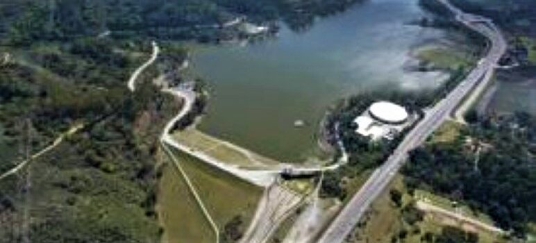
He led a tour of Oroville’s new spillways. At the top of the dam, at the main spillway, the water seemed to be slipping like a treadmill set to the highest speed. Far below, it hit a row of blocks known as dentates, creating a giant plume of water and mist that jumped into the air.
At the emergency spillway, the ground since 1917 has been covered in roller-compacted concrete, which forms a 1,200-foot-wide staircase that drops down the hill.
Yarbrough deflected the question of what would happen when the rebuilt emergency spillway was used for the first time. Yarbrough said they were still studying how much erosion would occur, though they expected some where the emergency spillway ended.
‘Extreme fatalism’
A type of fatalism crops up frequently in discussions of extreme flooding with state water officials.
During an event like ArkFuture, perfect operation of a dam would take the total inflow, which comes in peaks and troughs, and parcel it out evenly.
But most dams can’t even release large amounts of water until they are nearly full, and even the best forecasts won’t allow a dam operator to know what’s coming much more than five days in advance.
As flood control, dams are good at capturing single storms.
Send California 30 days of rain, and there’s not much they can do.
In 1986, during one of the worst floods Northern California experienced in the 20th century, Mike Dettinger was stranded on Point Reyes with a colleague and both their families, including Dettinger’s 9-month-old daughter.
“We were a bunch of groundwater hydrologists, and we knew there was a storm coming in but really had no sense of how bad it was going to be,” he said.
The families ended up driving their Cadillac across a flooded road and losing control of it. The two families spent the next night sleeping in a fire station and the one after that in the manager’s office of a local motel.
Getting people to believe the evidence in front them is the first step toward a solution, but it’s only the first step.
The threat to California’s dams is no longer akin to being surprised by a flash flood. It’s Dettinger in the Cadillac, heading into the torrent. The siren is blaring, but still we don’t change course.
A new vision for the future
Engineers could keep raising the levees, holding back the water as best they can. Dam owners could build more spillways like the one at Folsom or the ARC spillway planned for New Bullards Bar. And state authorities could get better at evacuations, start drilling for dam failures as we do for earthquakes.
Probably California will have to do all three. But climate change requires a different kind of adaptation.
What if, rather than trying to out-engineer the weather, or evacuate and return in an endless cycle, we changed where and how we live?
Americans aren’t good at retreating, and the ones who wound up in California, the cliché goes, are the people who didn’t stop pushing forward until they ran out of continent.
The Indigenous population, though, knew a floodplain when they saw one. Is it unimaginable that we might learn that lesson as we unlearn the ones of the 20th century?
Maybe this could be California:
It’s a drought year. The streams dry up. There’s barely enough water for the people and the crops and the animals, but because there aren’t too many of them, they survive. The next year it floods. The snow builds in the Sierra, storm after incredible storm, until the spring arrives and it all goes rushing out to the ocean. The people, though, live well above the rising water. The storms are intense, but after each one passes, the land around them, dun and brittle and dusty for years now, blooms with a million newborn flowers and endless gold-green grasses.
Christopher Cox is a writer with The New York Times Magazine. Copyright 2023, The New York Times. The original, longer version of this article appeared in the New York Times Magazine on June 22, 2023.
Isn’t this why the federal government ordered the reservoir in Morgan Hill drained because of a lack of action or just general ineptitude by CA in maintaining the dams and levees around it? Simulations and just common sense showed that if the dam broke 1 million lives would be washed away. CA did nothing. Feds ordered it closed. Thank goodness we had the feds to protect us from our state and local agencies.
Let’s be realistic here. The dams were an issue due to poor leadership and maintenance – everyone knows infrastructure in CA is horrible, and many other parts of the country. That is the real issue, not “climate change.” The climate is going to change regardless of if humans are here or not – but while humans are here, they can do a MUCH better job of, instead of complaining, fix the bridges, roadways, dams, grids, etc.
It’s that simple.
Gee, what happened to those trillions of infrastructure dollars Joe Biden had to have?
New wall around the Delaware house?