
The National Weather Service forecast for the greater San Francisco Bay Area for Monday calls for up to 80% chance of rain with patchy fog in some areas during the day, and up to 40% chance of rainfall with thunderstorms during the night.
Daytime highs will be mostly in the 50s to lower 60s on the coast and inland, and in the upper 50s on the coast. Overnight lows are expected to be mostly in the upper 40s, with some areas around the bay dropping into the lower 50s.
Forecasters say post frontal rain showers with a slight chance for thunderstorms will continue today. Rain showers are expected to linger into Tuesday before gradually decreasing from north to south.
A flood advisory was in effect until 4am today in the counties of San Francisco, San Mateo, Santa Clara and Santa Cruz, while a flood watch was also issued until Monday morning in portions of central and northern California.
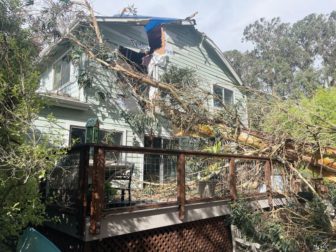
Falling eucalyptus tree renders Santa Cruz County home uninhabitable this weekend. Photo by Todd Guild.
A high wind warning for the San Francisco Peninsula Coast, Santa Cruz Mountains, Eastern Santa Clara Hills, East Bay Hills and Northern Monterey Bay expired at 8am, after a high surf advisory for the entire shoreline from Sonoma County down to Monterey County expired at 4am.
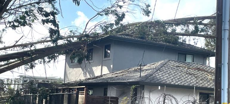
The number of PG&E customers in the Bay Area affected by power outages Monday morning has edged down from a high of more than 400,000, but more than 200,000 utility customers were still affected as of 8am.
A total 219,828 are without power across the region, according to PG&E's latest report. The number is down from an earlier report at 5am, when 235,407 customers were affected.
The North Bay remains the hardest hit, with 69,334 without power. There were 69,129 customers affected in the South Bay, 50,116 on the Peninsula; 26,557 East Bay and 4,692 in San Francisco.
Statewide, from 8am Sunday through 8am Monday, PG&E officials said power has been restored to 918,000 customers -- nearly 68% of customers impacted by this storm
A power outage closed Cal State East Bay's campus in Hayward, officials said Monday morning.
The university is open remotely, according to officials, who clarified that classes are not canceled.
Both Oakland and Concord centers are expected to operate normally for the day.
At the height of Sunday afternoon’s winds, more than 20 Bay Area weather stations recorded gusts over 80 mph, the National Weather Service said.
The strongest gust was 102 mph, recorded at 4:40pm at Pablo Point, near Nicasio in Marin County.
The top of the list, as of 8 pm Sunday:
- Pablo Point, 102 mph, 4:40 pm
- Road to Ranches, 99 mph, 5:40 pm
- Loma Prieta, 98 mph, 2:35 pm
- KNPT Towers, 97 mph, 3:30 pm
- Pine Mountain Fire Road, 96 mph, 2:50 pm
- Soda Springs Road, 96 mph, 4:40 pm
- Gunsight Fire Road, 96 mph, 5:30 pm
- Point Reyes, 89 mph, 2:20 pm
- Lucas Valley, 89 mph, 4:10 pm
- Los Gatos, 87 mph, 5:32 pm
- Mount Umunhum, 85 mph, 3:20 pm
- Mount Diablo, 83 mph, 4:30 pm
- Mines Tower, 82 mph, 6:50 pm
- Richardson East, 81 mph, 5:50 pm
- Mount Alison (Mission Peak), 81 mph, 3:50 pm
Gusts above 80 mph were also recorded in Napa and Monterey counties, the weather service said.
San Jose officials had issued a proclamation of local emergency Saturday night as up to 2 inches of rain were forecast for the city Saturday and Sunday.
Homeless people living along the Guadalupe River were ordered to evacuate, the city said in a report on preparations for the arrival of a so-called atmospheric river.
Other unhoused people were offered free rides to a shelter at Roosevelt Community Center, 901 E. Santa Clara St. An additional shelter was prepared at Camden Community Center.
Rainfall in the Santa Cruz Mountains feeds into the Guadalupe River, which runs through downtown San Jose.
The city advised moving vehicles to higher ground if parked in a potential flood area.
The public was advised to stay indoors and avoid unnecessary travel through the weekend.
Over the weekend, the city announced road closures:
Road Closures:
- Boulder Drive and Claitor Way closed south of Suncrest Avenue due to a downed tree and power lines.
- Chula Vista Drive closed at Chula Vista Court.
- Alum Rock Falls Road closed.
Other Impacts:
- Alum Rock Park closed until further notice.
- Kelley Park, including the Japanese Friendship Garden and Happy Hollow Park and Zoo, closed.
The weather said this weekend’s “Atmospheric River event” will continue to produce multiple rounds of heavy rainfall to parts of southern California including the Los Angeles Basin through Tuesday. Dangerous small streams, urban and river flooding, mudslides, strong winds and high surf will all be possible. Heavy snow is also expected to the Sierra Nevada.
San Jose Inside and Good Times contributed to this report.
Hopefully the 40% chance of that materializing ends up being an overestimate, but I’ll be sure to secure any loose outdoor furniture just in case.