
The National Weather Service forecast for the greater San Francisco Bay Area called for up to 100 percent chance of rain throughout Friday, with gusts as high as 30 mph expected to be experienced in most areas of the region.
Forecasters say high surf will continue to batter the coast ahead of the next system, causing some coastal flooding issues. The next system will impact the region today and Saturday, bringing gusty winds and periods of moderate to heavy rains.
Forecasters said there is also a slight chance of thunderstorms in the region, mainly tonight and Saturday. Another round of high surf is expected to impact the region on Saturday, with more coastal flooding possible.
Unsettled weather is expected to continue as a series of storms aim at the California Coast. The next more significant storm may impact the region in the middle of next week, according to forecasters.
“Expect a challenging Friday evening/night if out,” the weather service warned. “Those with the option to leave work early or work from home, may want to consider this option.”
On Thursday morning, the Bodega Bay buoy reported a significant wave height of 28 feet. The Point Reyes buoy came in at 26 feet and the Point Sur had 29 feet.
High waves battered beaches and sea walls along the coast, from Half Moon Bay to Capitola, including Santa Cruz and Aptos.
The Santa Cruz Wharf reopened Friday morning, according to an update posted on the City of Santa Cruz and the Santa Cruz Wharf Instagram pages.
“All inspections are complete and the Wharf is now open to the public. The end of the Wharf had restricted access due to the damage. Follow all signage and stay out of restricted spaces,” read the post.
This came a day after the wharf was closed to the public, as large waves pummeled the walkways and damaged pilings below, causing a fire sprinkler loop to rupture.
A coastal flood warning was downgraded to an advisory on Thursday afternoon and will remain in effect through 2pm today due to a combination of high surf and potential storm surge, according to the weather service.
High winds expected on Friday have prompted the weather service to issue a wind advisory for parts of the Bay Area.
South winds of 15 to 30 mph, with gusts up to 40 mph are possible from 7am to 7pm Friday, forecasters said.
The advisory covers the Sonoma Coastal Range, North Bay interior mountains, North Bay Interior Valleys and Santa Clara Valley, including San Jose.
Evacuation orders were put out for areas around Stinson Beach in Marin County on Thursday morning, though the orders were lifted around 1:45pm.
Evacuation warnings also lifted Thursday for Santa Cruz County residents in the areas of Capitola Village, Pajaro Dunes, Seacliff State Beach and Rio Del Mar where the high surf caused flooding in multiple coastal areas of the county.
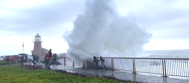
According to Alexis Clouser, a meteorologist with the weather service, some coastal areas are seeing 28- to 33-foot breaking waves that have caused flooding, road closures, and evacuations.
The worst of the swells happened Thursday morning.
Clouser stressed that even though evacuations might be lifted and conditions are becoming less dramatic, everyone should steer clear of the waves.
Images of wave watchers being engulfed by swells have been shared on social media Thursday, as well as intrepid surfers taking advantage of the massive waves at Mavericks Beach, a world-famous surfing site in El Granada in San Mateo County.
“We do want to encourage people to stay away from the water and it's not a safe time to be in the water or near the water -- the conditions are deadly,” said Clouser. “Please stay off rocks, piers, jetties. It's very unsafe and you can easily be washed down by a wave.”