
Hopeful citizens banked on a wet few months of winter and got the opposite—a meager 2.34 inches of rainfall in Santa Clara County between January and March of this year. It was the Great El Niño Fizzle, sparked by the promise of increased ocean temperatures and extinguished by the trade winds which, in an El Niño event, need to slacken so all that warm water will slosh back to our side of the Pacific.
Organizers of Santa Cruz’s Titans of Mavericks big-wave surf contest have already been printing T-Shirts that say “EL NIÑO IS COMING,” and residents from the seaside to the South Bay are rightly excited for larger-than-average swells in the coming months. A much-belated El Niño is coming—the first in 18 years—and it may be the strongest since 1950, when oceanographic monitoring began.
“It’s right on schedule,” says Nate Mantua, Ph.D., a climate scientist for NOAA’s Southwest Fishery Science Center. “I checked [last week], and temperatures in Southern California are about 5 degrees Celsius warmer than normal, or almost 10 degrees Fahrenheit warmer than normal. Local waters are 5.5 degrees Fahrenheit above average, or in the low- to mid-60s, depending what the wind is doing.”
It’s Nov. 3, and Mantua’s office, which he shares with a 63-pound taxidermic king salmon, is awash with late afternoon sun and the briny smell of the Pacific.
The oceans are warming, the trade winds have already died down, and the usually bone-dry Atacama desert in northern Chile and southern Peru is blooming—a telltale sign that El Niño is upon us. There’s just one thing: if El Niño was, in fact, a boy child gathering strength inside the womb of the Pacific, his sonogram would be atypical, to say the least. Admittedly, there’s that unmistakable band of warm water bulging along the equator—El Niño’s hallmark—but there are also large masses of warm water, creatively dubbed “the warm blob,” extending, as we have never seen before, from coastal U.S. and Mexico as far north as Alaska.
“We’ve got this incredible warming of the higher latitudes of the Pacific Ocean,” says Mantua, “and ocean temperatures have been record-high for the last two years. That makes this year unlike anything in our historical record.”
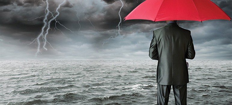
The anomalous “warm blob” is raising many questions about climate change and our future—including what this year’s El Niño winter will be like. Warmer oceans mean stronger storms and increased odds of above-average winter precipitation. But just how much rain is the boy child planning to bring us? It is enough to replenish our parched land? Will it unfold slow and steady like applause or come in fits and torrential downpours, unleashing landslides, floods and hurricane-force winds like the ones that tormented California’s not-so-distant past?
“We know that no two El Niño events in the past have been the same, even though a lot of attention is being put on what happened in 1997-98 and 1983 [El Niños], because of similarities in the strength of this event to what those two events had, but there is no guarantee that we’ll see a repeat of all of the things that might stand out in people’s memories,” Mantua says. “Odds are there will be some surprises.”
Even with advanced technology—which includes some 70 buoys moored in the depths between Japan and the California Coast—climate prediction is a field riddled with unknowns, probabilities and conservative estimates. The saying goes, climate is what you predict and weather is what you get. But one thing is certain: it’s going to rain this winter. Possibly a lot. And maybe, in a way Northern California hasn’t seen in decades.
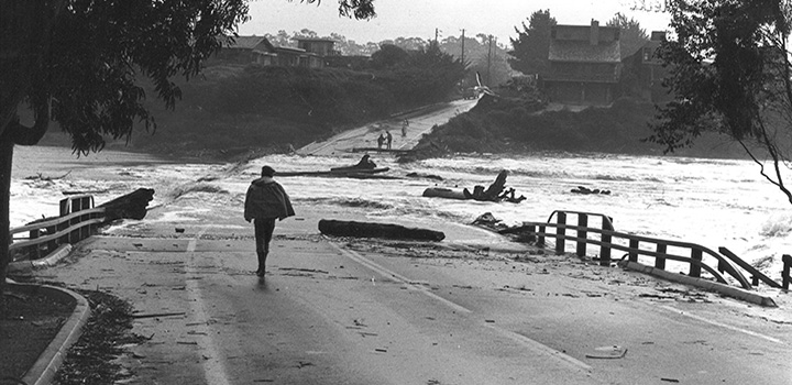
Coastal roads were decimated during the winter storms of 1982. (Photo by Greg Griggs)
Stormy Past
In early January of 1982, a storm sat over the Santa Cruz Mountains and the Bay Area. The rain began to fall during the last quarter of the NFL championship game between the San Francisco 49ers and New York Giants, pouring through the night and into the next day. At its peak, it dumped 17 inches of rain in a 28-hour period on Lompico. Already saturated by slow and steady rainfalls in the weeks prior, the steep hillside of Love Creek in Ben Lomond liquified, ripping houses from their foundations and claiming 10 lives.
“All you saw were trees sticking out and cars and pieces of houses, and it was right after Christmas so there were Christmas decorations, and there were 10 people buried under it all,” says Gary Griggs, Ph.D., Distinguished Professor of Earth and Planetary Sciences at UC-Santa Cruz, where he’s taught since 1968. He was the first geologist on the scene the morning after the storm. “They never found them,” he says. “Actually, one woman survived, she grabbed onto a tree as it went through her house at one in the morning.” To this day, residents of Love Creek still decorate a Christmas tree to remember those who died in the storm.
In the winter of 1997-98, massive flooding claimed the lives of 17 people in California. East Palo Alto was one of the hardest hit cities in the Bay Area, as the San Francisquito Creek overflowed and damaged a reported 1,700 homes. Many were trapped inside as all that surrounded the exteriors were lakes of mud water after a steady month of rain. Those were El Niño years, which is a level this winter doesn’t even need to reach for dire consequences.
“You don’t have to have an El Niño year to have a really devastating winter,” Griggs says.
According to a study published in the Journal of Coastal Research, about 76 percent of the storms between 1910 and 1995 that caused significant erosion and structural damage along the California coast occurred during El Niño years.
We still don’t really know why it happens, but when the trade winds—which normally blow toward the equator from the northeast and southeast—die down, it allows the warm water in the Western Pacific to flow back toward the coast of South America and then up the coast.
“The first thing it does is change the climate on opposite sides of the Pacific,” says Griggs.
That means drought in places like the Philippines, New Guinea and parts of Australia, as well as heavy rainfall in the eastern half of the tropical Pacific. Some of these shifts are already happening, according to Mantua.
“For instance, right now, the Atacama desert in southern Peru and northern Chile is blooming. They’ve had lots of rainfall the last couple of months. And that’s a part of the world that has some of the driest deserts on Earth in the absence of these El Niño periods. It can go years without any appreciable rain at all,” says Mantua, who notes that the same is true for the Galapagos Islands.
During El Niño winters, which typically peak in December and continue through January and February, periods of active storm development at the same latitude as Central and Southern California have sent storms barrelling into the West Coast, says Mantua. This happened in the ’82-’83 and ’97-’98 El Niño years, but we have also had lots of storms like this in some non-El Niño years, he points out.
One concern is that the ominous warm blob could potentially add fuel to storms as they develop in their breeding ground between Hawaii and the Aleutians.
“When we have big storms that do develop and move across that water, they’re going to have strong winds, and they’re going to evaporate a lot of water off that surface,” says Mantua. “They’re going to cool that warm blob, but in the process, they’re going to fuel themselves up. So, I do think that our storms are going to be warmer and stronger than they otherwise would be without that vast area of warm water.”
Coupled with elevated sea levels typical of a warmer ocean, the more direct westerly wave approach of El Niño winters delivers an extra blow, and potentially vast flooding.
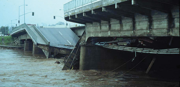
A bridge over the San Lorenzo River was no match for the 1982 El Niño. (Photo by Greg Griggs)
Thirst for Rain
El Niño isn’t synonymous with rain, per se. Four out of the last six strong El Niños brought wet winters to California, says Mantua. But NOAA’s Climate Prediction Center is calling for “increased odds” of a wet winter in Northern California—to the tune of a one-in-three chance of having a wet winter, and a less than one-in-three chance for having a dry winter. And while the odds for a wet winter increase toward Southern California, the Gulf Coast and Florida, there’s just a 5- to 10-percent shift in the odds for a wet winter for the Central and Northern Coast, says Mantua.
“It’s pretty subtle,” says Mantua, “but that is the nature of climate forecasting.”
Would a wet winter end our drought?
“While the precipitation outlook suggests good news for California, one season of above-average rain and snow is unlikely to erase four years of drought,” says Mike Halpert of NOAA’s Climate Prediction Center. “The drought outlook shows that some improvement is likely in Central and Southern California by the end of January, but not drought removal. Additional statewide relief is possible during February and March.”
The average annual rainfall in Santa Clara Valley is about 15 inches, according to data from NOAA. During the El Niño storm through 1983, the valley received about 30 inches of rain—double the yearly average. In the El Niño months of 1998, we received 28 inches of rain.
“There was good snowpack in the Sierras, and if we had a repeat of those kind of winters it would definitely put a dent in the drought,” says Mantua. “It wouldn’t wipe out all of our water supply deficit, it wouldn’t recharge all of the ground water that’s been pumped out in the last four years and the last dozens of years, but at least it would help refill reservoirs and recharge our soils and get a snowpack established again in the mountains.”
El Niño was identified by fishermen in Peru and Ecuador as far back as the 1600s—not so much for its weather patterns as for its negative impacts on fishing. The warm waters shut down nutrient-rich upwelling, halting the plankton bloom and subsequently breaking the entire food chain. But El Niño’s warm water can also mean weak upwelling in local waters, too, which could mean poor reproduction this year for Dungeness crab, which are also being plagued by the warm blob’s algae bloom of toxic domoic acid.
The warm water isn’t great for Pacific salmon either, which thrive in cold, upwelled water high in nutrients and a productive plankton community that includes lipid-rich copepods, and other crustaceans like krill, says Mantua.
“During these warm periods we know that it can be stressful for top predators, including salmon, seabirds, sea lions and seals,” says Mantua. Salmon released from hatcheries, which produce most of the salmon caught off the coast of California, are usually fished after they’ve been in the ocean for two or three years, says Mantua, “So it doesn’t have such a big impact on the season that you’re in, but two or three years down the road.”
Similar to past El Niño years, bluefin tuna, opah or moonfish, and bonito—marine life typical off the coast of Southern California—are all currently swarming local waters.
Since the last El Niño, Santa Clara County has experienced almost two decades of relatively mild winters, and Griggs points out that only a small portion of today’s residents were even here to experience the full wrath of an intense storm season.
“It’s like all earthquakes aren’t the same—all floods aren’t the same, and all El Niños are not the same. I’m not sure if people fully understand that,” says Griggs. “I think in terms of flooding, what people are doing is trying to clean out storm drains and get sandbags ready and make sure your roof gutters are clean, which helps the water get out faster.” Even so, “You can’t stop sea levels from rising and you can’t stop the waves from coming,” says Griggs.
San Jose Inside staff contributed to this report.
> “It’s right on schedule,” says Nate Mantua, Ph.D., a climate scientist for NOAA’s Southwest Fishery Science Center.
NOAA?
http://www.washingtontimes.com/news/2015/nov/26/lamar-smith-noaas-climate-change-science-fiction/
Oh. THAT NOAA.
Slow news day?
This article says exactly nothing! Take out the ‘maybes’ and the ‘what ifs’ and the contradictory statements that hedge all bets, and we have nothing more than rank speculation.
And can someone please explain what this means:
NOAA’s Climate Prediction Center is calling for “increased odds” of a wet winter in Northern California—to the tune of a one-in-three chance of having a wet winter, and a less than one-in-three chance for having a dry winter.
So we have about a one-in-three chance of having a wet winter? And also a less than one-in-three chance of having a dry winter? What the hell does that mean?? Does it mean we now have a two-in-three chance of having the opposite of each one? Huh?
And:
Warmer oceans mean stronger storms…
Another sciency-sounding assertion, which has nothing to do with storm intensity. Storms become stronger when the differential between warm water and cold water is greater. It has nothing to do with global warming. And if the warm water is below 80ºF, tropical storms, hurricanes, etc., cannot even form. You would think the writer would understand the basics.
Next:
…advanced technology—which includes some 70 buoys moored in the depths between Japan and the California Coast
More misinformation. The reference is to the ARGO buoy network, which consists of some 3,340 submersibles that record many different parameters from different ocean depths, and radio the information to satellites. There are several hundred of the buoys between Japan and California.
The ARGO system shows that beneath the surface, there has been no global warming at all. But since NOAA and similar government agencies have their marching orders requiring them to promote the “man-made global warming” narrative, they falsely claim that global warming is chugging along as predicted.
But it isn’t: satellite measurements (the most accurate global temperature data we have) shows conclusively that global warming stopped almost twenty years ago! Oops.
This article is nothing more than speculation. Everyone likes to talk about the weather. But the fact is, we don’t know what this winter will bring. No one does — as we see from the quotes in the article. We’ll find out when it happens, not before.
There’s probably a ‘one-in-three chance’ of something happening. Or not. Time will tell; but the NOAA won’t tell, because they just don’t know.
* * *
[BTW, that’s a great link from SJOUTSIDETHEBUBBLE above. Worth the quick read. Gov’t bureaucracies like NOAA have been totally politicized. For a much more objective view, readers need to go online. An excellent source for weather-related articles is: WattsUpWithThat.com , which has won the internet’s “Best Science & Technology” award for the past 3 years running.]
All you need to know:
1. “WORLD LEADERS PLOT WAR ON ‘WARMING'” [Drudge Report]
2. Fear! Fear! Fear!
3. Carbon tax, energy taxes, global taxes, tax, tax, tax.
Well, maybe one more thing you need to know:
http://www.telegraph.co.uk/news/earth/environment/globalwarming/11395516/The-fiddling-with-temperature-data-is-the-biggest-science-scandal-ever.html
“The fiddling with temperature data is the biggest science scandal ever”
> Drudge Report: “WORLD LEADERS PLOT WAR ON ‘WARMING’”
If I wrote the news . . .
SECRET CONCLAVE OF CRIME BOSSES EXPOSED IN PARIS
PENTAGON RULES MYSTERIOUSLY BAR DRONE ATTACKS
What’s the over/under on how many hours after the first big storm Jenn will give us a sob story about some family that didn’t buy flood insurance and is now homeless due to flooding?
Bye bye drought