
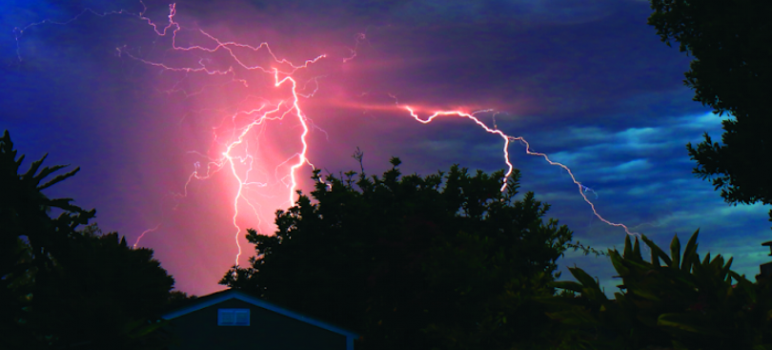
Last summer’s wildfires had Silicon Valley glued to its screens to track multiple blazes as they encroached from different directions.
Visibility and air quality dropped as a thick cloud of smoke settled over the valley. By August 20—just four days after the first of thousands of “dry lightning” strikes sparked hundreds of fires across Northern California—the SCU Complex Fire prompted evacuations in the East San Jose foothills, on its way to ballooning by 40 percent the next night to an incredible 230,000 acres. Meanwhile, the CZU fire was devastating the Santa Cruz Mountains, forcing tens of thousands to evacuate in Santa Cruz and San Mateo counties.
Locals needed a constant flow of information over the subsequent days and weeks to answer very immediate questions—what areas are being evacuated? What percentage has been contained?
Once the flames were doused, however, other questions began to arise, bigger questions about how these wildfires started, and their lasting effects on our landscape and way of life.
So we asked the UCSC Science Communication Department—one of the most prestigious science-writing programs in the country—to answer some of the questions submitted by readers about everything from the explanation for dry lightning to the danger of mudslides in the mountains. Here are their answers.
—Steve Palopoli
What causes dry lightning? The lightning strikes seemed unnatural and otherworldly. Is it possible that weather engineering was involved? Climate change?
Our August dry lightning storms were spectacular and rare, but not unnatural. Rather, a tendril of moist air from a tropical storm off the coast of Mexico created perfect conditions for the mesmerizing sky show that lit the CZU complex and at least 500 other fires across the state.
The term “dry lightning” is misleading. In such storms, thunderclouds make lightning the same way they always do. The difference is that rain falling from these clouds evaporates before it reaches the ground. Because of this, dry lightning is infamous for its potential to light wildfires.
But that doesn’t happen often here. The Bay Area sees lightning on average just 1.5 days each year. Thunderclouds need a ton of warm, wet air to form—think late afternoon storms in humid Florida. The Pacific Ocean, with its chilly waters just offshore, acts like a wet blanket that smothers massive clouds before they can build up.
But in August, “it was a matter of everything lining up for a disaster,” says veteran Bay Area meteorologist Jan Null. High winds swept a steamy plume of air from tropical storm Fausto northward toward the Central Coast. Thunderclouds billowed when this moist blanket hit high temperatures from our summer heat wave. That same dry air shielded the ground from rainfall as many of us watched the storm break overhead. In the Bay Area alone, 1,026 lightning bolts met parched earth.
Meteorologists hesitate to link any one event to climate change, although models do predict that storms like Fausto will grow more intense. Lightning storms may also become more frequent as the planet heats up.
Scientists can’t say how these changes will impact the Bay Area specifically. But regarding the August storms, Null is clear on one thing: “The whole concept of ‘weather engineering’ is from the realm of science fiction and conspiracy theories, with no basis in fact.”
— Freda Kreier
Is it true that some fires can smolder as embers inside of trees for days before combusting? If so, how does this happen?
Embers from a distant fire can settle in living trees and burn without a visible flame—smolder—for weeks. Lightning strikes can also spark smoldering, creating a delay so wildfires break out days after a thunderstorm has passed.
All fires need three things: an ignition source, fuel and oxygen. If these elements are present, but in the wrong amounts for a full-fledged flame, a fire can smolder instead. Often, oxygen is limited or the fuel source might contain a lot of moisture, like a young living branch, says environmental scientist Will Russell at San José State University, who studies how forests recover from wildfires.
Smoldering above ground can happen in trees if there’s a buildup of partially decomposed leaves—called “duff”—nestled in the branches or a hollow. But usually there’s enough oxygen that such fires will either ignite or blow out. It’s much more common for a fire to smolder underground in root systems for weeks or even months, allowing it to spread long distances undetected.
Although smoldering is a slower and cooler type of burn than flaming, it still damages forests and releases greenhouse gasses into the atmosphere. Smoldering trees also can ignite into flames under the right conditions.
To understand how this happens, Russell says, imagine sitting around a campfire. “We’re trying to roast our marshmallows, and the fire is not really going. So what do we do?” he says. “Everyone starts blowing on it.” In the same way, hot dry winds can give smoldering fires the rush of oxygen they need to ignite.
For homeowners who live in wooded areas at high risk of fire, Russell recommends keeping an eye out for smoking stumps or roots—especially ones that appear to be caving in—and to water them thoroughly. If you notice smoldering higher up in a tree near your property, he says, call the fire department and leave immediately.
—Stephanie Melchor
How do firefighters decide the best places to take a stand against an expanding wildfire?
“Control lines,” the trenches in the war against a wildfire, are where firefighters battle to halt encroaching burns. Crews construct them by clearing vegetation and digging up soil. They may also commandeer preexisting firebreaks, like rock outcrops or roads. Dozens of factors affect where firefighters set control lines, but topography is critical.
“Our preferred method is to go direct on all fires,” says Cal Fire Santa Cruz/San Mateo Unit Chief Ian Larkin. But if confronting the blaze directly is too risky, fire crews harness the landscape—in particular, ridgelines.
Wildfires race up slopes as they dry fuels ahead of them, but flames travel slower downhill. Firefighters exploit this by positioning control lines just below the tops of ridgelines. There, they combat flames that come over the ridge.
But ridgelines don’t always hold. When the CZU fire swept past the ridge above Boulder Creek, firefighters took advantage of roadways and the Fall Creek Truck Trail, slashing new control lines to link the features—or as Larkin calls it, “connecting the dots.”
Existing roads and trails help firefighters act quickly, but often the initial attacks take much more time. On the fire’s first day, Aug. 16, crews had to cut up to 1,000 feet through woods just to reach the flames—while awaiting reinforcements in a state stressed by multiple summer blazes.
As the blaze threatened the western edge of Santa Cruz, Cal Fire used grassy areas in Wilder Ranch State Park to bulldoze 8-foot-deep control lines from Empire Grade down to Highway 1. Meanwhile, in the rugged mountain forests, chainsaw-wielding firefighters labored step-by-step in the smoky air to carve out their lines.
Fickle winds can dramatically accelerate a fire, so firefighters must be ready to adapt. Sometimes, control lines don’t cut it. When winds spurred the fire near Boulder Creek on Aug. 18 and 19, fire crews resorted to “life preservation,” says Larkin: “We had so few resources that we couldn’t do anything but get as many people out of the way as possible.”
—Nikk Ogasa
What are the chemical effects of fire residue on lakes, rivers, and the ocean? Did the ash acidify our water supply?
When we extinguish forest fires on land, the problems are just beginning in water. Ashes and burnt debris that fall from the sky or wash into streams and rivers can add toxins, heavy metals, and damaging levels of nutrients to aquatic ecosystems. And yes, ash acidifies our water supply—but it can be treated.
Fire has shaped California’s landscape for millions of years. But today’s fires are increasingly severe and happening near urban areas. The worst ones incinerate houses, cars, and industrial buildings, spewing manufactured chemicals into the air. What’s more, forests absorb industrial pollutants from nearby cities that can vaporize when fires burn through. As a result, we see elevated levels of heavy metals like mercury, aluminum, iron, lead, and arsenic in nearby bodies of water after big fires.
Burned trees, plants, and dirt create other problems. “Nitrogen, phosphorus, and carbon are the basic building blocks of biology,” says forest hydrologist Kevin Bladon of Oregon State University, who studies wildfire impacts on freshwater ecosystems. Charred soil flowing into ponds and rivers throws the levels of those nutrients off balance, he says—creating massive “fertilizer dumps” that can cause algae blooms. Those blooms deplete oxygen and choke out other living things. Seawater chemistry near the shore may also change when “black carbon”—made when fossil fuels and organic matter burn only partway—washes into the ocean. However, scientists don’t have much data on this.
Impacts on our drinking water supply are unavoidable, but fade over time. “Ash and dissolved organic carbon will acidify the water,” Bladon says. Although it can get costly, treatment plants are set up to clarify such tainted water. Depending on the cause and degree of contamination, plant managers will add chemicals or use different types of filters. The Santa Cruz Water Department recently switched to carbon filters, for example, to extract organic sediments and lingering odors from the water.
Technicians constantly monitor water sources for such fluctuations in quality and adapt their treatments as needed, says Chris Coburn, deputy director of the city of Santa Cruz Water Department.
—Emily Harwitz
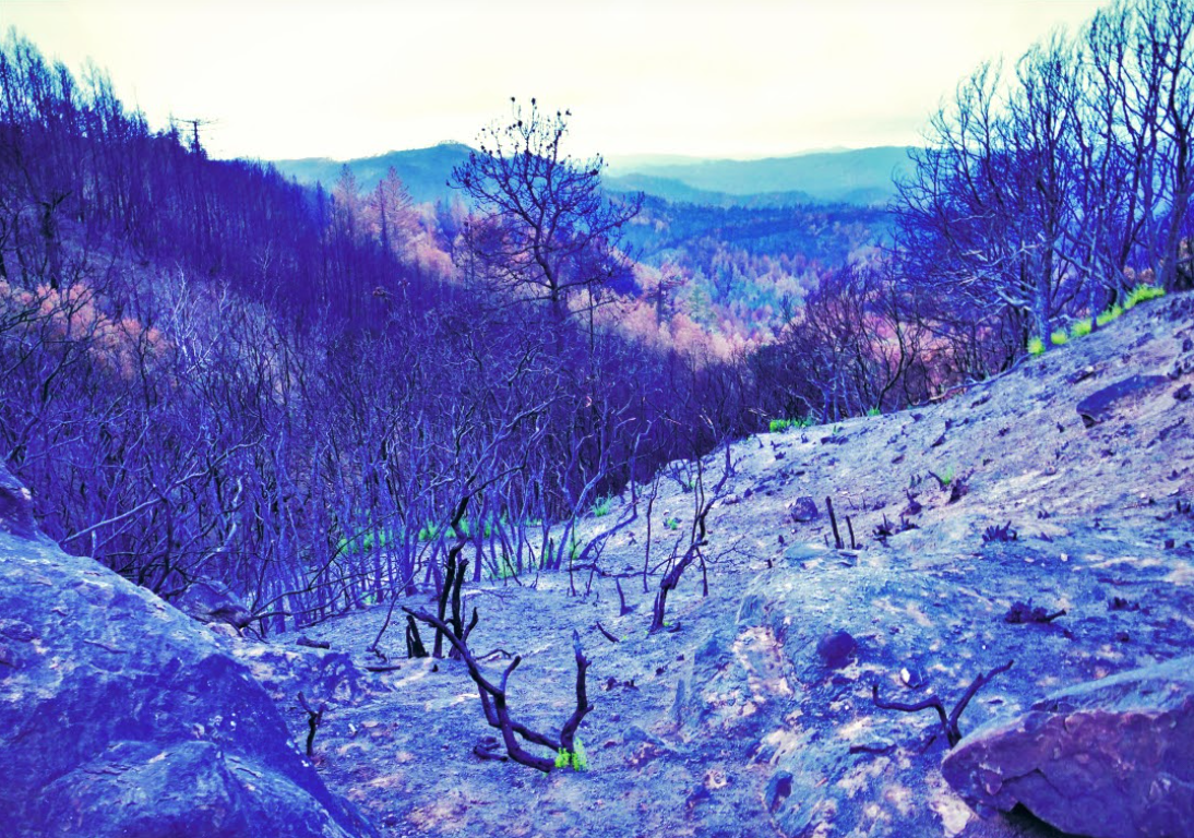
SLIPPERY SLOPES Scorched hills in the Santa Cruz Mountains now lack a dense understory of plants, making them vulnerable to erosion and debris flows. (Photo by Cypress Hansen)
What is the likely impact of ash from burned homes, cars, plasma screens, etc. on our organic gardens, specifically the fruit and veggies we consume? Should we be concerned about toxicity?
If your garden is in a directly burned area, the California Department of Public Health recommends not eating the produce. But outside of the burn zone, your post-wildfire fruits and veggies are almost certainly not toxic.
When a fire burns homes and cars, the resulting ashes are considered more toxic than those from forests. Ashes from structures and technological products can contain dangerous contaminants, such as lead and other heavy metals.
After the Tubbs fire burned through urban areas in Sonoma County in October 2017, the University of California Cooperative Extension received an influx of questions about local produce safety. “We started asking around, and there really was very little research—a void in information around the effects of urban wildfire on produce safety,” says food systems advisor Julia Van Soelen Kim.
The group gathered a research team and conducted tests on more than 200 samples of leafy greens from over 25 sites near the fire zone. Analyses revealed no evidence of heavy metals, and at all but one site, no detectable levels of other dangerous chemicals such as dioxins and furans, which can lurk where garbage and wood burn.
Despite these “good news findings,” Van Soelen Kim acknowledges there could be chemicals outside the lab’s detection capabilities. She advocates for further scientific research on toxicity at more sites close to major fires.
Despite the low risks of consuming fire-related toxins along with your greens, you still should take protective measures to avoid inhaling ash while gardening. If the air is smoky, wear an N95 mask when you go out to harvest. Be careful not to kick up ash in your garden, especially with a leaf blower, and use drip irrigation to prevent ash from splashing onto plants.
Finally, wash your hands before and after harvesting—and of course, clean your produce before cooking with it.
“First and foremost is protecting your lungs,” Van Soelen Kim says. “Ingesting ash is a very low concern.”
—Allison Gasparini
How many animals died in the fires, and will we see more wildlife coming into populated areas as a result?
We may never know how many of our furry and feathered friends perished in the fires. Estimating this would be a huge undertaking, says wildlife biologist Terris Kasteen of the California Department of Fish and Wildlife.
“We don’t have baseline numbers of what was there to begin with to make a comparison of what’s there now,” Kasteen says.
Our local wildlife ranges from the tiny tick to the mighty mountain lion. Fires have radically different impacts on each group. For example, insects feast on burned vegetation and thrive after fires. Rodents can survive fast-moving fires in their burrows, but lingering flames might suffocate them.
Birds and large mammals, on the other hand, need to leave. Their survival hangs on what lies outside the burn zone. Animals usually can avoid fires and then recolonize their habitats afterward. Researchers with the Santa Cruz Puma Project saw this in action: All three mountain lions with tracking collars near the CZU fire zone moved safely out of the way.
But some escape routes for wildlife are vanishing as the state’s population spreads out and develops more land. “As a result, some organisms like birds and deer have fewer places to find refuge,” says fire ecologist Jon Keeley of the U.S. Geological Survey, stationed in Sequoia National Park.
This habitat fragmentation will “almost inevitably” drive wildlife into populated areas, Keeley says: “Any place I’ve seen big fires juxtaposed with developed areas, the urban environment ends up seeing a lot more wildlife in their backyard.”
Managing forests more wisely and reducing human-caused ignitions, such as power-line failures, are essential to tamp down wildfires, researchers agree. But they also urge us to put animal risks into perspective. A lot of our plants and animals have coexisted with fire for many years,” says Richie King, a field technician with the Santa Cruz Puma Project. “These forests will come back.”
—Isabella Backman
How much damage can you really do to your lungs by exercising on a day that the air quality has been deemed “unhealthy” due to smoke from wildfires? Is wildfire smoke worse for your lungs than the smog in L.A., which contributes to around 150 “unhealthy” air days per year?
We’ve been cooped up at home in a pandemic. Our state is smoldering from its worst fire season. We’re stressed, and that daily jog or bike ride keeps us sane. But huffing and puffing by exercising in smoky air threatens your lungs, even if you feel fine at the time.
“When you exercise, your muscles need more oxygen, so you breathe more,” says pulmonologist John Balmes of UC San Francisco, physician member of the California Air Resources Board. Breathing heavily draws in more of the microscopic particles that swirl within wildfire smoke, inflaming delicate lung tissue.
The most harmful airborne particles, denoted as PM2.5, are less than 2.5 micrometers wide—nearly 50 times smaller than a grain of sand. Such minuscule smoke particles can burrow deep into your lung’s air sacs, where they wreak havoc on immune cells.
You’re also likely to breathe through your mouth rather than your nose when exercising, Balmes says. Mucus membranes in your nose filter out pollutants by trapping them like flypaper, a function the mouth can’t match. You would need a tight-fitting N95 or P100 respirator mask to block these tiny particles, not just a loose cloth mask.
Ultimately, your risk depends on your health status and how smoky the air is. Experts discourage outdoor activity when the Air Quality Index (AQI) is in the purple range. “That’s hazardous even to healthy people,” Balmes says. People who are elderly, pregnant, or have heart or lung diseases should be cautious when it’s orange or red. Even brief smoke exposure can trigger asthma if it’s in your family history and you have allergies.
As for L.A.’s smog, its main ingredient—ozone—also inflames airways and reduces lung function. But it’s hard to compare the risks of ozone and smoke. Balmes notes that conducting a controlled health study near a wildfire is no easy task.
If you smell smoke or see haze in the air, check your local AQI at airnow.gov or purpleair.com.
—Tess Joosse
How have forests adapted over time to survive wildfires? Will the forests burned in the CZU fire now be more vulnerable to new fires as they regrow?
Forests in the Santa Cruz Mountains, particularly the iconic redwoods and mixed evergreen forests, survive wildfires with protections that have evolved for millions of years. Heat, flames, and even smoke prompt responses in trees and plants in neighboring habitats that help them recover quickly—although droughts can make fire damage more severe.
Fire defense often relies on the ability of a species to resist disease, so when fire strikes, it’s healthy and ready. Redwoods are tough because of “compounds in the wood that make it really resistant to insects, pathogens and burning,” says Michael Loik, an environmental scientist at UCSC.
Many adaptations kick in after trees have burned or even succumbed to the flames. To reproduce, some evergreens depend on fire, such as the knobcone pine. Its pinecones only spew their seeds when scorched by heat.
Similarly, redwoods depend on wildfires to procreate successfully. Flames remove dead leaves around the base of the tree, “which are full of pathogens that kill the seedlings,” says ecologist Gregory Gilbert at UCSC. This cleansing-by-fire leads to “seeds germinating to produce healthy redwood seedlings,” he says.
Some species, such as fire poppies in coastal chaparral habitats, store their seeds in pods underground that lay dormant for years. They only germinate when fires singe the soil. Other forest plants, such as poison oak, survive wildfires by having an extensive root system that keeps them alive.
But are burned forests more vulnerable to new fires? It’s complicated. There isn’t a simple yes or no answer, Gilbert and Loik agree. It depends on the extent and severity of the flames, as well as which plants burned. According to Loik, the most important factors in a wildfire’s severity are “large-scale winds, upslope winds, topography, temperature, humidity and fuel load.”
Fuel supply is key: Managing a forest’s underbrush and clearing clutter with controlled burns can keep the next wildfires from getting out of hand. Reducing the explosive intensity of fires is our best tool in helping forests recover quickly.
—Carolina Cuellar
Why have the fires increased the danger of landslides and mudslides, and can anything be done to help prevent or minimize them?
Imagine trying to hike downhill through a dense thicket of brambles. Now, think of bounding down a clear trail on an open hillside. In the same way, rainwater runs freely down terrain scorched by fire as it erodes the freshly exposed soil. On the charred forest slopes, a wet winter season poses a great risk to residents of the Santa Cruz Mountains.
California is no stranger to landslides. In 1982, the deadliest storm in our county’s history collapsed 1,000 feet of hillside in Love Creek Heights, burying homes and killing 10 people. And after the Thomas fire in late 2017, heavy rains triggered a massive slide in Montecito that destroyed 400 buildings, killing 23.
Although current trends point to a drier-than-usual winter here, a half-inch of rainfall within 30 minutes could trigger debris flows—the most common type of landslide in the wake of wildfires.
Debris flows are “fast-moving slurries of sand, cobbles, boulders and water,” says Jeff Prancevic, a landslide expert at the U.S. Geological Survey in Menlo Park. Picture a flash flood of rocky cement moving up to 30 miles an hour.
Ashen slopes within the CZU burn zone no longer have an understory of ferns, tanbark oaks and berry bushes to trap and hold water and soil. Free of obstacles, rain will schlepp dirt and pebbles into gullies. If the soupy mixture picks up speed, it will sweep up boulders and branches, barreling downhill until it spreads onto flat ground.
Debris flows follow the path of least resistance, making streambeds prime targets. “Be aware of those places,” warns Prancevic. “If your house is near them, don’t be there when it rains.”
Trying to deflect a debris flow with barriers just creates more projectiles, says Santa Cruz County spokesman Jason Hoppin. Instead, he stresses having a plan to leave safely. The county has geared up to provide ample warning, Hoppin says: “Evacuations are based on weather, and we’re pretty good at predicting weather.”
Text SCR911 to 99411 to receive alerts and visit community.zonehaven.com to learn about your evacuation zone.
—Cypress Hansen
This is really important for all of us. Writing articles about such events is very important because fires and other disasters are very scary. On my site, I am currently working on reading reviews of services where professional writers can help me write my essay on forest fires and how to avoid them. I liked the Papersowl review and I hope for their great help and that I will soon boast of my cool essay.