
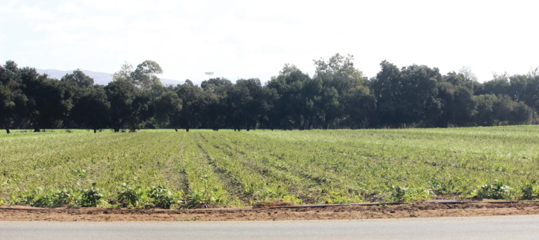
A Southern California developer has proposed to annex 194 acres of agricultural land in southwest Gilroy and build up to 1,195 residential units, according to a conceptual plan submitted to Gilroy officials in July.
The proposal, in the early stages, could take years to play out, as the plan must go through various considerations by multiple agencies as well as public comment periods before a shovel could ever hit the dirt.
The City of Gilroy is currently searching for consultants to prepare documents such as an environmental review, service plan and fiscal impact. Consultants are invited to submit proposals by Oct. 20.
Newport Beach-based Integral Communities submitted an application to amend Gilroy’s Urban Service Area boundary to add the acreage to the city’s limits. The property, located in southwest Gilroy, is bordered by Thomas Road and Santa Teresa Boulevard to the west, near Gavilan College, West Luchessa Avenue to the north, Uvas Creek to the east and Mesa Road to the south.
“Gilroy’s inventory of readily developable residential land is dwindling and will reach a critical shortage even before the SND can be annexed, entitled and made ready for development,” the application states, adding that the Hecker Pass Specific Plan area and Glen Loma Ranch are expected to be fully built out in the next few years. “Having a readily available supply of land is critical to meet the City of Gilroy’s anticipated housing needs. Once annexed and entitled, the SND project will be an important source for various housing types and affordability levels for many years.”
The developer states in its application submitted by Evan Knapp of Integral Communities that the project could build “659 to 1,195 residential units including compact single-family detached homes, zipper lots, townhomes, duets and apartments designed to meet a diverse range of income types.”
Referred to as the South Neighborhood District, a conceptual plan included in the application shows multiple parks as well as a buffer zone between Uvas Creek and adjoining farmland.
The application is signed by representatives of more than a dozen families who own various portions of the property.
The proposal has generated discussion among Gilroyans, many of whom have questioned whether the plan fits into the urban growth boundary approved by voters with Measure H in 2016.
According to Gilroy’s 2040 General Plan, the property is zoned Neighborhood District High, which allows for a mixed density of housing. It is also designated as an area within the urban growth boundary for future development.
Connie Rogers, chair of the Gilroy Growing Smarter group that put Measure H on the ballot, said the annexation process is complex and will take years to complete.
“All these steps will take years, and there will be opportunities for public comment all along the way,” she said. “So I would not worry too much yet. Wait until the EIR is released and then there will be a comment period where the public can ask questions and get answers.”
Once the environmental review and other documents are completed, the proposal will then head to public hearings held by the planning commission and city council, who will decide if the application can be submitted to the Local Agency Formation Commission (LAFCO). The city has to obtain approval from LAFCO, which oversees city boundaries, before adding to its service area boundary, according to a statement from city officials.
If LAFCO gives its OK, the project would then go through another round of public hearings with the planning commission and city council before consideration.
To view the city’s request for environmental review consultants, visit bit.ly/2YGPLbU.
no brainer, how much per door?
Naturally. The entire flatland there, east (Dunneville) to west, Gilroy to Hollister and San Juan Bautista, it’s all there for the developing.
Enough already!
Precious and irreplaceable farmland should not be developed for housing and or any other uses save food production for people and livestock.
David S. Wall
The farmland loss and related “sprawl” argument is seen still as applying to the Central Valley (by lefties who hate Big Ag and ag’s use of water, so often), and it’s the Sierra Club (who won the state its diamond lane beginnings long ago) that got Los Banos and everything between Gilroy and Merced made illegal for having a high-speed rail stop, combating that extended tech commuter shed concept now used by the project itself in place of competing with air travel for SF-LA.
Meanwhile, the northern San Joaquin Valley continues to be developed and the Bay Area’s commuter shed expanded greatly from what it was in its start in the late 1970s and early 1980s.
Everywhere in the Bay Area you see flatlands you can expect development, as a rule. The flatlands around Gilroy to Hollister are to be developed in the next “stage, especially with extra pressure from closing Coyote Valley for now, at least, to development.
This map also shows other things, including the need to fight hard if you’re anti-development in the North Bay as well, yes, including the classic wine country in Napa and Sonoma Counties, where some land could become vineyards or new housing tracts, depending on governing there.
http://gordonye.com/yegifs/newrelie.jpg
10,000 to 15,000 gallons of water use per home each month, times 1195 =11,950,000 gallons to 17,925,000 gallons. The wildlife has no where to go.
Stop the greed!
build build build
until there are no trees left
the only viable course of action with an open border
otherwise all our welcomed will be welcomed with $3000 a month rent