
Propped up at the wooden bar inside Vahl’s Restaurant and Cocktail Lounge, regulars sometimes wax poetic about Alviso’s historic heyday—when the hustling and bustling port city at the Santa Clara Valley’s northwestern fringe was like a South Bay version of San Francisco’s Pier 39.
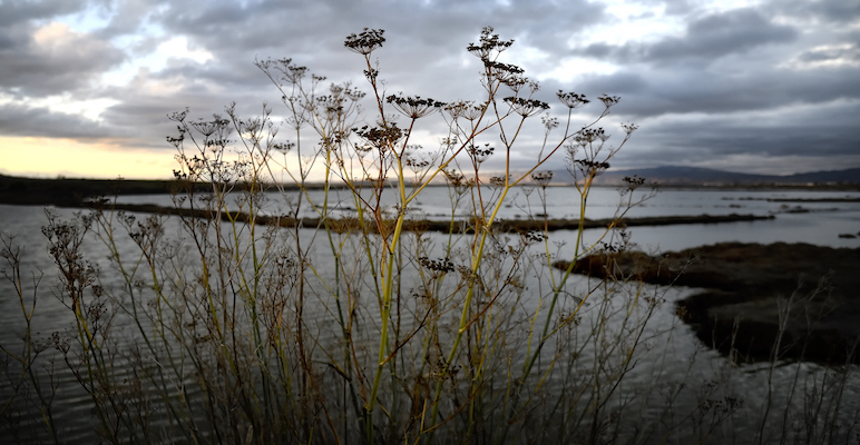
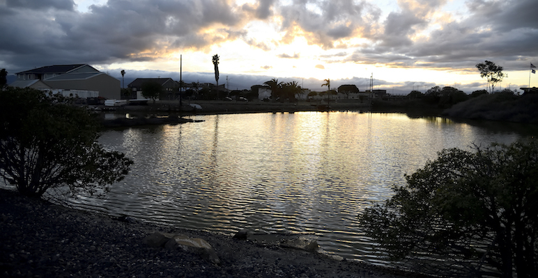
Today, residents say the small community is not the end of the world, but it’s certainly on the edge, butted up alongside tidal marshland home to ducks, egrets, seagulls, pickleweed, endangered salt marsh harvest mice and collapsing wooden structures boarded up with plywood.
When Amelia Vahl first heard of the property where she would start a restaurant in 1939, the story goes that she asked, “Where's Alviso?” Eight decades later, bartender Frank Rebozzi says Vahl’s remains somewhat of a local secret to everyone but a few dozen patrons—mirroring an episode straight out of Cheers, complete with a man named Norman perched on the corner stool.
“It’s home to a lot of people,” Rebozzi says, pointing out original murals and wall decor that transports patrons back to another century, only a few miles away from the heart of Silicon Valley, which ushered the world into the technology age. “It's rare that somebody walks in that I don't know.”
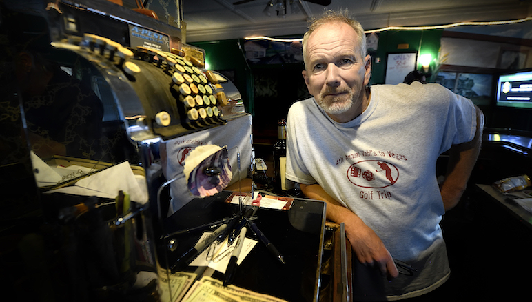
As bartender of Vahl's in Alviso, Frank Rebozzi knows almost all of the patrons that come in to the saloon his aunt opened in 1939. Photo by Greg Ramar
Annexed by San Jose in 1968 and home to barely 2,000 residents, Alviso is tucked 15 feet below sea level, between the confluence of ponds, sloughs and waterways at the southernmost part of the South San Francisco Bay, where it meets the Guadalupe River and Coyote Creek. Whether staring off into the Bay’s rippling waters or the shiny new high-tech buildings and hotels visible on the outskirts of town, there’s a calming stillness in the salty Alviso air, despite waterways historically choked with toxic runoff and invasive species—and a run-down business sector without promising investments outside of water treatment plants and regional landfills.
What has remained the same here is the seasonal flooding that has been a staple of the marshland’s history—from glacial meltdown forming the Bay’s shape around 18,000 years ago, to slough-side Ohlone villages harvesting salt and clams for centuries, to King Tides bogging down missionaries’ adobe homes in the 1700s.

Elva Ruiz began welcoming and serving customers at Vahl’s in 1984. After working in a cramped kitchen and dining room for decades, she’s now one of three staff members keeping the operation running. Photo by Greg Ramar
But in March 1983, El Niño storms wreaked the most palpable havoc after a muddy deluge engulfed the town in up to 10 feet of water for weeks. The toll of damaged structures was an estimated $6 million.
Amelia Vahl didn’t jump at the opportunity to resume operations, after water rose halfway up its walls in the flood.
“But she got letters from customers pleading for her to reopen again, so she did,” says Elva Ruiz, who joined her mother and stepfather working at Vahl’s the year after the disaster, at a time when the kitchen still served Italian-style fine dining, complete with a seven-course Sunday meal and two-hour wait times. “I think if that happened now, they probably won’t do that again.”
Since the pandemic, the infamous Pepto-Bismol pink dining room has remained closed, leaving patrons munching on snacks and whatever dinner Ruiz has made that night. Last weekend, the menu was lasagna and enchiladas.
In between games of golf on the single arcade machine, many Alviso residents shared their grudges against the bad reputation the town has acquired over the years: smelly, run down and a landfill for everyone else’s trash.
But others, like Rebozzi, save their breath, enjoying the peace and quiet that comes with being hidden away from the South Bay’s hotspots, while being thankful recent installations like tide gates and an 8-foot water drainage pump connecting the community’s center to the slough will keep the town dry—for now.
“It’s funny, you’ll get people to come in for the first time and go, ‘It’s such a small-town atmosphere, there’s nobody here,’” Rebozzi says. “But talk to people that lived here their whole life, who go, ‘It’s so fucking crowded.’”
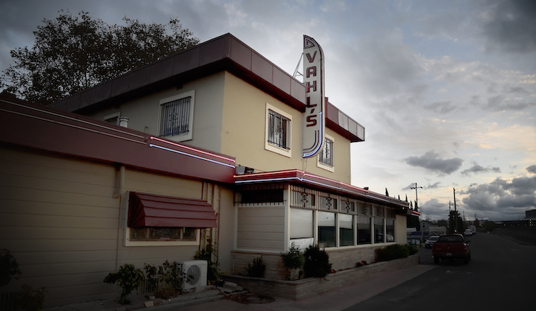
The murals, decor and feel of Vahl’s Restaurant and Cocktail Lounge, located at 1513 El Dorado St. in Alviso, transports patrons back to another era. Photo by Greg Ramar
A Dirty Project
Rechelle Blank has gleaned an encyclopedic knowledge of the issues that have plagued Alviso for decades during her nearly 30 years working for the Santa Clara County Valley Water Conservation District—an agency created in 1929 to combat the growing threat of floods—and nine years spent on the South San Francisco Bay Shoreline Project.
Blank says it’s a race against the clock to get ahead of a major storm that could put the region underwater again, so the shoreline and salt pond projects are working in tandem—balancing man-made flood management engineering with nature-based mitigation solutions.
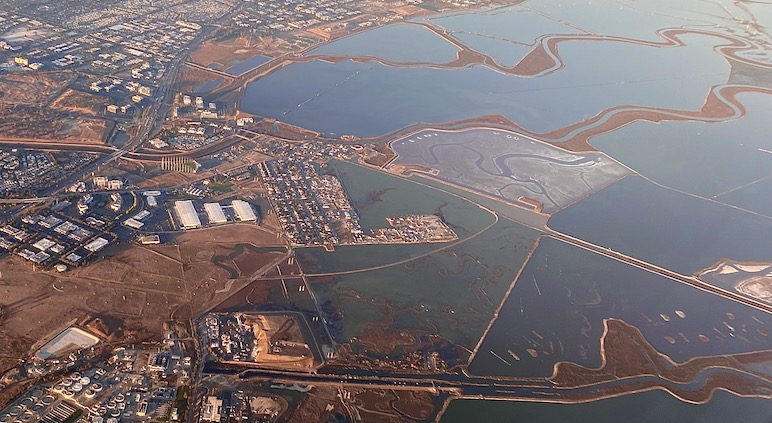
Alviso and the winding sloughs outside the town can be seen from planes coming in and out of Norman Y. Mineta San Jose International Airport. Photo by Katie Lauer
Specifically, gently sloped horizontal walls called “ecotone levees” can help restore the Bay’s wetlands and provide high ground for wildlife, mitigating flooding and erosion while the current levees—which aren’t up to federal safety codes—remain in place.
While navigating thick layers of bureaucracy made up of several governmental and environmental agencies, such as the Bay Conservation and Development Commission, is vital to ensuring effective projects, the sluggish timeline has led to costly delays. A feasibility study alone took four years before design and construction could begin on Phase 1 in 2015.
While working with the Army Corps of Engineers was supposed to ease financial strain on local jurisdictions, their strict requirements for material placed where the land meets the water doubled initial estimates, now pricing the specially engineered dirt from $50 to $70 per cubic yard. Blank says federal monies approved in 2018 to fund the undertaking is capped at $124 million.
While a seemingly simple “dirt project,” that dirt ain't cheap.
The sheer amount of material of the levees and ecosystem restoration were estimated to run $194 million in 2015. Now six years later, that price-tag is $545 million—nearly triple digit growth—for only four miles of levees.
Having originally committed to shell out $54 million for the project, Valley Water is now left footing the skyrocketed bill.
Comparatively, Foster City spent $65 million for six-and-a-half miles.
Local governments, environmentalists and residents are working to return natural habitats to the South Bay's shores. Photo by Greg Ramar
Fortunately, 70% of voters across nine counties approved Measure AA in 2016 to utilize parcel tax revenue to help chip in $500 million over 20 years towards the project’s costs. Additionally, United States Sen. Dianne Feinstein, who helped purchase the salt ponds with $100,000 in federal cash in 2003, has requested another $1.6 million in federal funding for Santa Clara County’s shoreline project, dedicated within the government’s budget through September 2022.
But both Blank and her Valley Water colleagues are frustrated that private entities, especially ones with fat pockets like Google, Apple and Facebook, may not pay a fair share for the protections the Water District is constructing.
“That’s a large gulp to swallow—to figure out which couch cushions you are going to look under to find the dollars,” Blank says. “What they say about the story of stone soup—everyone brings a little something and you can feed everyone—I really think for these projects, people need to start thinking that way.”
Mountain High, Valley Slough
Not nailing down a plan isn’t an option, as Santa Clara County has one of the highest risks of damage from tidal flooding in the state.
After an estimated 90% of the South Bay’s shoreline has already been lost to commercialism, development and erosion, Valley Water is tackling the herculean South San Francisco Bay Shoreline Protection Project, hoping to protect Santa Clara County’s 18 miles along the water from flood and erosion. At the same time, the South Bay Salt Pond Restoration Project is focused on returning the region’s former 100,000 acres of marsh to the water’s ecosystems. Together, the efforts work in tandem to bring the Bay back to its original habitats—or as close as possible.
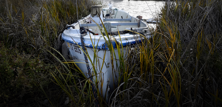
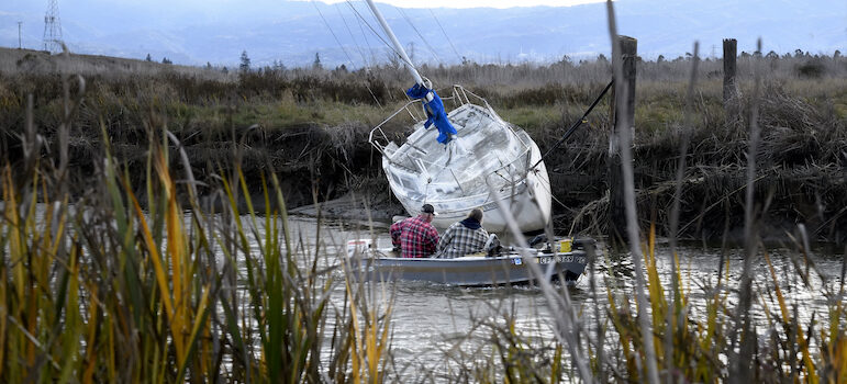
Small motorboats and sailboats can be seen traversing the Alviso Slough, while others have been abandoned. Photo by Greg Ramar
Phase 1 of the project—installing four miles of levees stretched in front of Alviso—has already taken 15 years to study, plan, contract and fund. But what was first billed at $194 million has ballooned into a $518 million project—a staggering 276% increase.
With the help of partners within the U.S. Army Corp of Engineers, California’s Coastal Conservancy and 40 cities across nine counties along the water’s edge, the goal is to identify and restore almost 15,000 acres of Bay Area wetlands in the former Cargill industrial salt ponds that colorfully ring the South Bay, stretching from the Don Edwards Wildlife Refuge’s shallow tidal wetlands to Google and Facebook’s high tech campuses on the western shores.
As development has crept ever closer to the water’s edge, hundreds of billions of dollars of buildings, homes and infrastructure are at risk. That includes the 70 properties Google purchased for campus expansions in the last five years in Sunnyvale and Facebook’s neighboring 57-acre campus worth $2.5 billion. Several other campuses like Oracle and Cisco are just a bit further inland.
But those catastrophic risks are better safeguarded than the historically marginalized communities that live, work and play in these sinking wetlands named after the first Spanish colonizer to claim the area home in 1775.
According to mapping from the San Francisco Estuary Institute, the risk stems from the fact that the South Bay is a “wide alluvial valley,” formed between parallel fault lines and ridges of the Coast Range. Its long, shallow and flat geological features boast an 8 foot tidal range that can hold massive amounts of water, most of which flows from the Sacramento and San Joaquin rivers.
Before the South Bay was dammed and diked, a “tidal prism” of fresh water mingled alongside salty tides from the Pacific Ocean flooding into the estuary’s mouth at the Golden Gate.
Roy Hays, director and former commodore of the South Bay Yacht Club, envisions a day when open bay waters return to the sloughs, allowing the club built in 1905 to recapture its glory days of hosting 50 boat slips along 440 feet of docks.
Hays says doctorate-level water experts estimate that change might happen within the next 50 years, as the South Bay Salt Pond restoration aids the return of native wildlife and vegetation. He can already see the water getting higher both at the club and when out duck hunting, as the tides flow up against the sloughs and yellow doorways along the marsh horizon.
“I have to give the Water District a kudos here,” Hays says, looking out at the water from the Yacht Club’s crow’s nest. “They have done a pretty good job of coming up with a whole master plan for this area.”
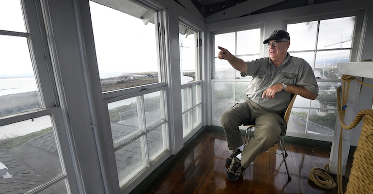
Roy Hays, director and former commodore of the South Bay Yacht Club hopes to return more boats to the Alviso's sloughs. Photo by Greg Ramar
But all of that depends on whether Alviso can keep its head above water—nature be damned.
According to Erin Zimmerman, a long-time environmental and political activist with the Climate Reality Project’s Silicon Valley Chapter, the sea level has risen 8 inches since 1900, and estimates say another 1.2 feet is possible in the next two decades.
An August 2020 report from the California State Legislative Analyst’s office painted a “worst-case scenario:” sea levels in the Bay rising anywhere from 3 to 7 feet by 2100.
These risks are compounded by more frequent and more intense storms, such as atmospheric rivers; researchers predict a three-foot flood has a 68% chance of occurring before 2030. That could reach 100% by 2050.
“I want to see our yacht club become more of a yacht club,” Hays says. “I’ve always said we’re not going to be happy unless we have boats.”
‘There’s a Train Wreck Coming’
As if skyrocketing costs and rising tides weren’t enough for the Bay and Alviso to weather, environmental experts have warned of a looming dirt supply shortage crisis from California to the Mississippi River.
That’s a problem, since an estimated 477 million cubic yards of mud and dirt are needed for the South Bay’s levees to stay above rising water levels within the next century. That’s the equivalent load of up to 48 million dump trucks loaded with dirt, which began arriving within the salt pond berms adjacent to Alviso’s marina in 2018.
Those heaps and mounds of dirt are necessary, after the land physically sunk as groundwater was pumped to irrigate the Valley of Heart’s Delight’s blooming orchards. Once the aquifers were depleted, Alviso reached its final resting place 15 feet below (current) sea level.
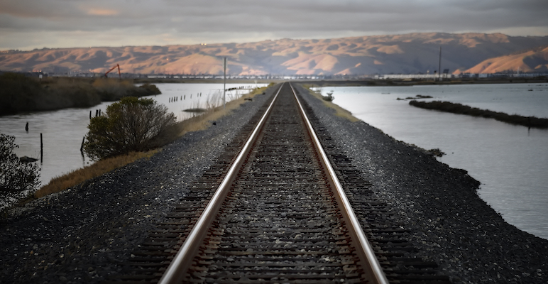
Tracks of the Union Pacific Railroad, which contributed to Alviso's economic downtown, still operate alongside the water's edge. Photo by Greg Ramar
But Blank says if maps of the South Bay’s shoreline from 2005 and 2018 were overlaid, nothing has really changed yet. Even after construction waited for planning, researching, contracting and permitting to be completed, the contractor hasn’t started tackling the former salt pond berms, currently only hauling in and stockpiling dirt.
“That material wasn't any kind of engineering placed to serve any purpose,” Blank says, adding that costs double the original estimates halted that progress. “It was kind of like ordering an extra light bulb for your car's headlight for when it goes out.”
Before those shovels get back in the ground in Spring 2022, researchers from the Stanford Woods Institute for the Environment published findings in 2021 that a seawall building outside of San Jose would force 36 million cubic meters of water—enough to fill 14,400 Olympic sized pools—to be redirected somewhere else.
Anne Guerry, chief strategy officer and lead scientist for Stanford’s Natural Capital Project, says installing levees and sheet panel walls—like the ones protecting Foster City, for example—in the South Bay would be “the single worst thing we can do,” adding that one high tide could potentially inflict upwards of $723 million in damages from flooding in cities from Redwood City to Napa.
Blocking tides with sea walls has a history of success, whether outside cities like New Orleans, Louisiana after Hurricane Katrina in 2005 or the ancient Roman Empire, when Constantine the Great had marine barricades constructed to safeguard the city of Constantinople in 448 A.D. But Guerry explains those benefits aren’t the same, since the Bay is an enclosed system, rather than open towards a body of water as massive as the Pacific Ocean.
“The bay is like a giant bathtub; if you start building walls in one part of the bay preventing water from getting into that part of the bay, that water is going to go somewhere else,” Guerry told me. “It takes a very long time to get from San Jose to Napa, and so I think people kind of process things at the scales at which they experienced them—not thinking about the whole bay as a system.”
Shoreline restoration and levee protection projects are hoping to keep the bay's waters from creeping up in developed areas in the South Bay. Photo by Greg Ramar
That bathtub analogy gets even more complex, as past successful solutions may not withstand climate change’s impacts on water temperatures, sea levels and storm intensities.
Yet meetings between government agencies Valley Water and the city of Sunnyvale show that seawalls are a part of years-long plans to tackle this issue. And that creates a difficult position for local decision makers: wait for the entire Bay Area to get a plan together or act locally now?
Guerry’s not suggesting people in Alviso and surrounding communities not protect themselves and their livelihoods, but rather explore creative, complex solutions like managed retreat, which the Netherlands employs to make more room for its rivers to safely expand.
Even though that policy is less attractive (and almost implausible) in Silicon Valley, where families have lived for generations, multi-billion dollar companies are headquartered and available, affordable space to relocate nearby is scarce, Guerry says any plans need to pay careful attention to which communities are making flooding worse and which ones are bearing the brunt of the impacts.
“I just feel like there's a train wreck coming,” Guerry says. “I think that we have to show less hubris about where we develop and how much control we have over the environment around us.”
But for Dick Santos—the area’s Valley Water director, whose family has lived in the town a century—the idea of abandoning Alviso due to its aquatic vulnerabilities is a terrible concept to ponder. He argues the difficulties are worth embracing in order to preserve Alviso’s history as the gateway to Santa Clara County’s prosperity, especially after decades of what he considers as neglect from San Jose elected officials.
“This project is very complex, even though we're talking about dirt,” Santos says, applauding Blank’s tenacity in preventing the whole project from potentially going under. “For me—being born and raised there and losing everything I owned in 1956, ’58, and ’83—I'm just excited because climate change and tidal flooding is real. We’re just doing so much good for the environment, protecting people and property—it’s so vital and I've been blessed to be part of it.”
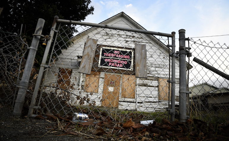
Several structures in Alviso are boarded up and abandoned, whether due to both natural and financial disasters. Photo by Greg Ramar
Blank says new research papers don’t throw a wrench in current plans; that’s mainly because decisions made during years of agency meetings are more or less set in stone for the first three phases of construction, and differences in perspectives are a common occurrence in this work.
“I don't want to say we're stuck, but I just have to keep pedal to the metal,” Blank says, adding that her team would rather learn lessons as projects are built. “We just have to keep looking for the golden side of the situation.”
Additionally, she’s confident in the Army Corps of Engineer’s research, which requires that any plans they pursue in the Bay avoid flooding entirely.
“There's always going to be new data that makes you have to rethink something,” Blank says. “But if we had done that, if you look at all the projects Valley Water has completed, we would never get anything done … We're going to be successful here, because this is what we've been aiming for since 2005.”
Residents, businesses and livelihoods have all put their faith in the efforts to keep the village below the sea alive and dry.
But even if Alviso ends up underwater someday, just like the former 24/7 bar at Sutter’s Place and the Alviso Speedway, local muralist and Vahl’s regular Emmett Dingel framed the predicament eloquently in white paint on one of the saloon’s walls: “Only Gone If Forgotten.”
Stop building and maintaining (read subsidizing) properties below sea level. Problem solved ???
Funny how the pictures show boats that were once in the water sitting high and dry while fretting over the sea lever rising :)
The title is misleading ‘Climate-Fearmongering’ – as the article states, Alviso, the lowest point in the SF Bay Area, is below sea level, on marshland, protected by levees – the greatest risk is not a ‘rise in sea levels’ – the risk is Floods due to large rain storms/ (ie, the pineapple express) – and rivers overflowing.
—————–As the ‘experts’ have been warning for Decades…———-
…“Entire nations could be wiped off the face of the Earth by rising sea levels if the global warming trend is not reversed by the year 2000.”
Noel Brown, UNEP Director
…“A billion people could die from global warming by 2020.”
John Holdren, Obama’s Science Czar
…“inaction will cause, by the turn of the century, 2000, an ecological catastrophe which will witness devastation as complete, as irreversible as any nuclear holocaust.”
Mustafa Tolba, Exec Director of the UN Environment Program
…“European cities will be plunged beneath rising seas as Britain is plunged into a Siberian climate by 2020.”
Paul Harris, 2004, UK Eco-Journalist
Quit complaining, buy a boat and learn how to swim.
Dick Santos has been on the Board of Directors for the Santa Clara Valley Water District longer than ‘King Tut’ has been dug-up and placed on tour.
There will be plenty of ‘dirt’ once the Bart tunneling will begin and…don’t forget ‘Mount Bart Dirt’ already standing tall in the Lagoon area of the Water Pollution Control Plant.
David S. Wall
“As Sea Levels Rise, Who Will Pay to Protect and Restore South Bay’s Shore?”
Middle income taxpayers for the most part and mostly brought on by themselves and the tenants of the properties they own through new property taxes they all approve.
Take money targeted for levees and pay businesses and homeowners for a planned retreat from rising water – the ocean is bigger than all of us, so levees are not a long term solution. Pay well enough so displaced homeowners and businesses can buy, at the least, a reasonably sized condo or storefront in a nearby community. You know we (citizens) are going to pay for this eventually. Why not be in front of the curve for a change?
As Rechelle Blank reported during an October joint meeting of Valley Water and the Sunnyvale City Council, the recent reassessment of the cost estimate for the Alviso Shoreline levee will only cover the distance from Alviso Slough to Artesian Slough. It will not cover the project-approved distance extending to Coyote Creek, leaving San Jose’s Regional Wastewater Facility unprotected. That facility serves eight cities. Valley Water is committed to finding funding to complete it, costs unknown, at least publicly. Plus who knows when?
Alviso is Santa Clara County’s version of the Lower Ninth Ward. Lucky for the residents and businesses that we don’t get hurricanes here.
Much smarter people can comment about the facts and the other nonsense.
To me, Alviso is and will always be a magical corner of a lost paradise that burns a whole in my nostalgic heart.
Long live Alviso, bring back the boats, I will always wish my path had lead there!